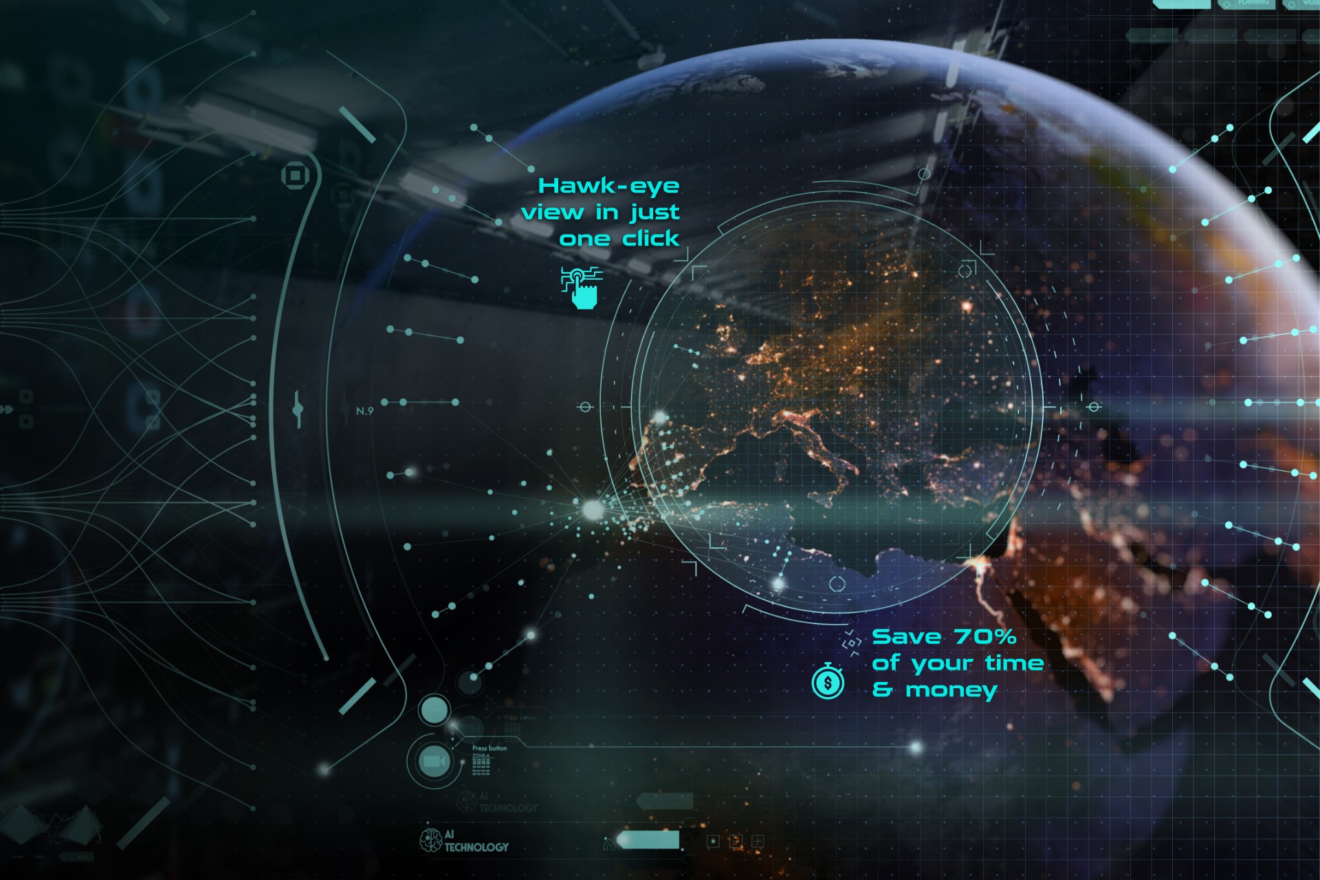
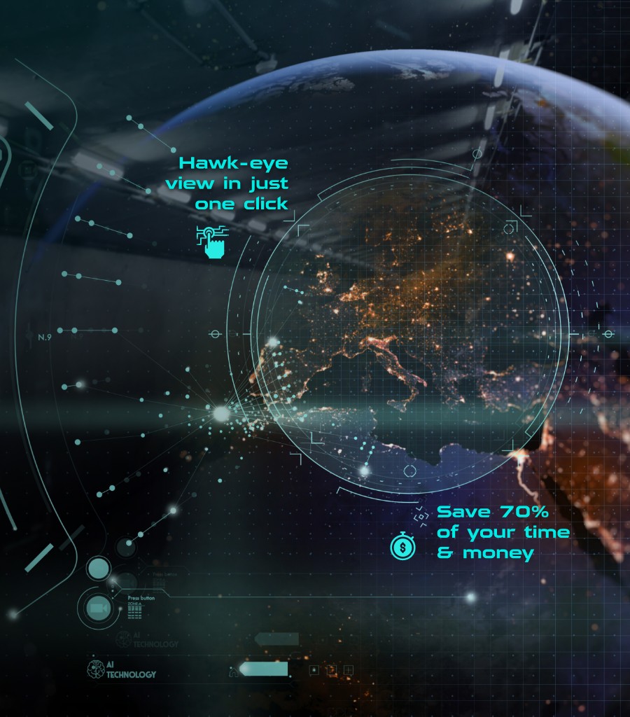
Our new offering in satellite image segmentation Telescope, powered by Azure, can be integrated seamlessly into Azure storage/database services and build customer-oriented applications to minimize geospatial analysis challenges.
During the last few years, the number of satellites has exploded exponentially. While there were fewer than 20 remote sensing satellite launches in 2008, in this year alone, there have been greater than 150. The amount of data being acquired from satellites is also increasing thanks to the falling costs of electronic components and machine vision exponentially, along with increasing private sector participation. As per a recent report, the global geographic information systems (GIS) market is expected to reach US$13.6 billion in 2027, up from US$6.4 billion last year.
In parallel, Artificial Intelligence (AI) has also been maturing quickly in the last few years, allowing organizations worldwide to automate drawing insights from vast quantities of data at a faster pace than ever before. A vast trove of satellite image data is waiting to be utilized for value generation across multiple domains varying from real estate, military, agriculture, urban planning, and disaster management, to name a few. This is where Affine seeks to add value with our home-grown tool, Telescope®.
What is Telescope®?
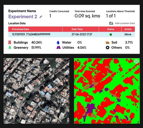
Telescope® is a next-generation AI satellite image segmentation solution capable of resolving complex business and significant operational requirements. Telescope® uses an in-house developed machine learning framework to classify information from a satellite image into one of the following six categories: buildings, greenery, water, soil, utilities, or others. This AI-generated output segmentation data can be utilized for diverse business purposes such as pattern identification and object tracking.
How can Telescope® help businesses?
Telescope® emphasizes the concept of leveraging AI and has established a software package that utilizes Azure cloud services to allow you to extract valuable data pertaining to your business. This platform lets users perform image analysis on high-resolution satellite images and view adjacent locations with the accurate coverage percentage of greenery, land, buildings, and water bodies. It makes use of information that can be compared to the street-level dimension. For example, it can differentiate buildings, whose size ranges from tens of meters to utilities, such as roads that run in meters.
Microsoft Azure role in Telescope®
Azure helps us to make effective use of cloud computing. When using Telescope®, we don’t need to use the model for inference on a real-time basis but as the demand arises. So, the businesses will be charged only as per the number of instances utilized. At the same time, the user history and information are to be accessed much more securely and restrictedly. Azure’s enhanced flexibility makes it easier to deploy the application. Using Azure Functions, we can also ensure that Telescope® scales automatically as the usage may fluctuate over time.
During the model training, Azure ML was quite useful in bringing down costs. The model training involved close to 1000 images being marked for segmentation. This involves a large pipeline of cleaning, labeling, and analyzing image data. Further, we had to train the segmentation model with tuning for various hyperparameters. It required using powerful GPUs. With Azure ML, we were able to allocate GPUs only for the duration of the training and thus bring down the cost. With Azure pipeline, we could automate the training process, bringing down the efforts effectively.
The results from Telescope are saved in comma-separated values (CSV) format, which can be seamlessly integrated with any Azure Database services. Using the information saved in these databases, we can effectively build PowerApps applications addressing the client’s requirements.
Azure Marketplace Consulting services for the AEC industry:
- Land Survey using Azure & Telescope®: Leverage Azure Services to conduct a land survey with valuable insights that can help convert the aerial dataset into a CAD site plan using our AI-based Land Survey consulting offering.
- AI-based Site Feasibility Study using Azure Service & Telescope®: Leverage Azure services for a feasibility study of your upcoming construction project using Affine’s AI-based Site Feasibility Study 6-week PoC consulting offering.
How can Azure-powered Telescope help the Architecture, Engineering, and Construction (AEC) industry?
- Architecture, Engineering, and Construction (AEC): One of the domains with vast potential for Telescope® is AEC. Site Feasibility Study plays a crucial role in the construction project management process. It helps companies map the road ahead and determine whether desired outcomes align with reality. Before going out to the field and examining, having a good estimate in hand will help determine the feasibility of a location quite early on. This can save the builder time and resources in capacity planning and impact assessment. With Telescope®, one can quickly estimate how the land is being used and to what possible areas a project can be expanded to.
- Property survey: Another area where Telescope® can contribute is real estate valuation. Before determining the specifics of the value, be it for insurance, rental, or sales/purchase, the interested parties would like to know about the surroundings of the buildings. These factors can influence prices a lot, such as the density of the buildings nearby, the presence of parks or lakes, access to the metro/highway, etc. This information is helpful for parties on both sides of the deal. Both parties can quantitatively obtain the details and use them for predictive modeling to get a fair valuation.
- Reconstruction post-catastrophic events: With the help of Telescope®, you can monitor and quantify the impacts of catastrophic events such as volcanic eruptions, wildfires, and floods, which can be used for emergency response as well as reconstruction. Regular satellite updates allow you to analyze how the destruction has spread and compare it with pre-catastrophe levels. In the case of reconstruction, using the segmentation data businesses can speed up the estimate process, which is the time-consuming part of the reconstruction.
Features of Telescope®
At the core of the Telescope® tool lies Affine’s proprietary backend deep learning algorithms. This state-of-the-art framework has several advantages. Our backend algorithms produce crisp object boundaries in regions that are over-smoothed by previous methods providing more accurate results. These algorithms’ efficiency enables output resolutions that are otherwise impractical in terms of memory/compute utilization compared to the other approaches; this allows us to use lower resources and pass on the lowered cost to the client.
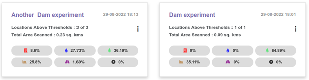
Another major feature that the Telescope® tool can provide is the simple interface. You can feed the geospatial coordinates (latitude and longitude) or select the location from the map to perform the analysis. Then the Telescope® tool will detect some area around that region (to the order of 0.1 square km) and perform the segmentation task. With such a simple approach, even someone not well-versed in geospatial analysis can start using the Telescope® tool with ease.
Telescope® is at its current state, a generalized solution to segment any kind of structure from satellite images used for different business requirements. Hence it can be adapted to other use cases with the added advantage of its quick integration and deployment using the solution APIs.
Role of AI in Telescope®
The AI revolution is impacting all sectors and opening a new door in geospatial analysis for business purposes. One common theme that we can see across all sectors is how it simplifies human effort. Before venturing out into the field, it helps you understand the problem’s complexity and how to approach it. For instance, in the real estate sector, it is impossible to perform any of the decision-making without going out to the field. However, this is a logistically expensive process. Instead, what if one can understand the property of interest and get the numbers all the while sitting in front of your computer? That too at a fraction of the cost of the field visit? This makes the decision-making process much faster while providing tools to do the reasoning transparently. This is what we seek to achieve with Telescope®.
Our vision: How are we envisioning Telescope®?
Telescope® is our major leap into geospatial analysis, which is very much in line with the vision of Affine: “to bring about the evolution of business decision-making through the adoption of the new in decision science and technology.” As a forward-thinking company, we have always believed in staying at the bleeding edge of decision science through a culture of celebrating excellence, continuous learning, and customer orientation. We strive to be a catalyst for business transformation underpinned by AI, Data Engineering, & Cloud. And Telescope® encompasses all these aspects.
That does not mean that we are at the end of our road. We pursue excellence to deliver the best possible results. Our approach and efforts are always backed with the intent of delivering improved customer satisfaction. With this, we share our vision for Telescope®.
Notably, anyone with access to the internet knows how to use online maps. Armed with such basic knowledge, they can also operate Telescope® quite easily. However, as customer requirements get sophisticated, the commonly available online mapping interfaces may not be enough and require more complex data analysis. We have designed our APIs so that, with minimal change, they can integrate more complex satellite data, be it open government databases such as LANDSAT and Copernicus or databases from a proprietary vendor.
- Time-dependent analysis: We can perform time-dependent analysis well with access to new datasets. Depending on the customer requirements and the data vendor, the frequency of data acquisition or access can change periodically. Once this is configured, Telescope® can easily process this periodic information. The results obtained can then be effortlessly monitored and analyzed suitably by the users.
- Fine-grained analysis: We also seek to enhance Telescope® with more fine-grained analysis capabilities. For example, when some buildings are detected in Telescope® to provide further details such as how high the building is. Or if some greenery is detected, if it is a forest or agricultural land, and if agricultural land, what sort of crop is used, etc. This multilevel analysis will provide more information, empowering the customer to make more nuanced decisions.
- Drone surveillance: We also consider another upcoming domain within a geospatial analysis, i.e., drone surveillance. Drones are gaining more popularity and sophistication. The time is not far when even drones are regularly utilized for geospatial analysis and progress monitoring in the AEC industry. We have designed our core model keeping this in mind. The image resolution we use for analysis is comparable to the images that can be acquired from drone-captured images. Tasks such as excavation and earthwork progress monitoring could be accomplished by analyzing the imagery. However, drones come in large varieties and diverse regulations in different countries. Hence, we intend to develop a standardized methodology for image acquisition, after which Telescope® will be able to process even drone-captured images.