Affine
AI Agent · Enterprise Productivity and Engineering
Telescope Agent

Transform High-Resolution Satellite Imagery Into Actionable Geo-Spatial Intelligence.

Satellite Imagery & Geo-Spatial Intelligence

Telescope Agent automates large-scale land analysis, infrastructure mapping, and topographical intelligence for faster, data-driven decision-making by transforming high-resolution satellite imagery into operational and environmental intelligence.

Telescope Agent
The Challenge

Geo-Spatial Intelligence Was Never Designed for Real-Time Scale

Organizations today rely heavily on satellite imagery and topographical analysis for infrastructure planning, environmental monitoring, land surveys, and asset tracking. Traditional geo-spatial workflows depend on labor-intensive manual mapping, slow survey cycles, and fragmented GIS analysis processes. Telescope Agent combines deep learning, satellite imagery segmentation, and geo-spatial intelligence to automate large-scale land and infrastructure analysis with high precision.

What Sets Telescope Apart

Traditional Geo-Spatial Workflows vs. Telescope AI

Traditional Geo-Spatial Workflows
Telescope Agent
Manual GIS mapping
Segmentation intelligence
Slow survey cycles
Real-time satellite analysis
Labor-intensive polygon tracing
Automated infrastructure mapping
Static environmental monitoring
Dynamic change detection
Fragmented spatial analysis
Unified geo-spatial intelligence
Limited scalability
Large-scale coordinate processing
How It Works

Multi-Agent Intelligence for Satellite Imagery Analysis

Telescope Agent orchestrates specialized AI workflows that continuously ingest, segment, classify, analyze, and visualize geo-spatial imagery for faster and more accurate environmental intelligence.

Live agent flow
Business Impact

Faster Surveys. Smarter Mapping. Real-Time Geo-Spatial Intelligence.

01

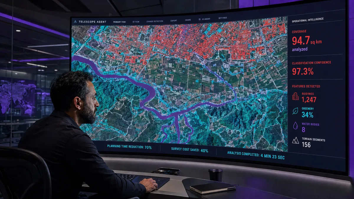
Reduce Planning Time by Up to 70%

Accelerate land surveys, topography analysis, and infrastructure planning through AI-driven geo-spatial automation.

02

Lower Survey Costs by Up to 40%

Reduce dependency on labor-intensive GIS mapping and manual field survey operations.

03

Improve Infrastructure Visibility

Generate high-resolution intelligence for buildings, roads, water bodies, agricultural land, and environmental zones.

04

Enable Real-Time Environmental Monitoring

Track urban expansion, deforestation, land-use changes, and remote infrastructure risks continuously.

05

Increase Geo-Spatial Operational Efficiency

Compress weeks of manual satellite image analysis and polygon tracing into hours through automated segmentation workflows.

06

Scale Large-Area Intelligence

Map wide survey areas from high-resolution imagery tiles (~300 m × 300 m each), stitched and classified by AI into large-area geo-spatial intelligence.

07
70%

Proven Geo-Spatial Performance

Telescope accelerates land surveys, topography analysis, and infrastructure planning, anchored to documented planning-time gains.

Industry Applications

Geo-Spatial Intelligence Across Industries

Industry01

Oil & Gas

Pipeline monitoring, remote asset surveillance, terrain intelligence, and environmental compliance tracking.

Industry02

Infrastructure & Urban Planning

Land mapping, zoning analysis, and infrastructure expansion planning.

Industry03

Energy & Utilities

Transmission corridor monitoring, remote asset inspection, and geo-spatial risk analysis.

Industry04

Agriculture

Crop monitoring, land utilization analysis, and agricultural yield intelligence.

Industry05

Mining & Natural Resources

Terrain analysis, excavation monitoring, and operational mapping.

Industry06

Government & Smart Cities

Topography intelligence, urban monitoring, and regulatory land-use governance.

Trust & Governance

Enterprise-Grade Geo-Spatial Intelligence Built for Precision and Scale

Telescope Agent combines segmentation intelligence, geo-spatial validation frameworks, cloud-scale processing, and responsible environmental intelligence workflows to deliver accurate, reliable, and enterprise-ready satellite analysis.

Get Started

Geo-Spatial Intelligence Should Move at the Speed of Change.

Deploy AI agents that analyze, segment, and transform satellite imagery into real-time operational and environmental intelligence.