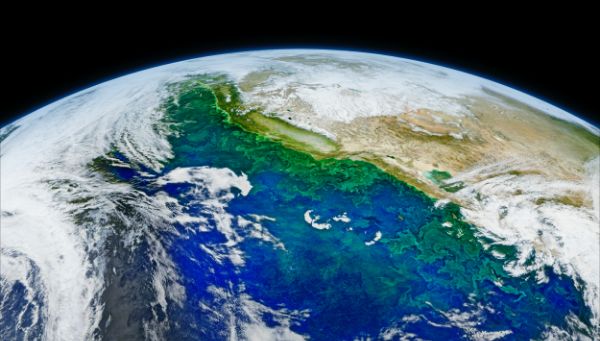
Stop! This next-gen AI satellite image segmentation solution could solve your business problem in 12-20 seconds.
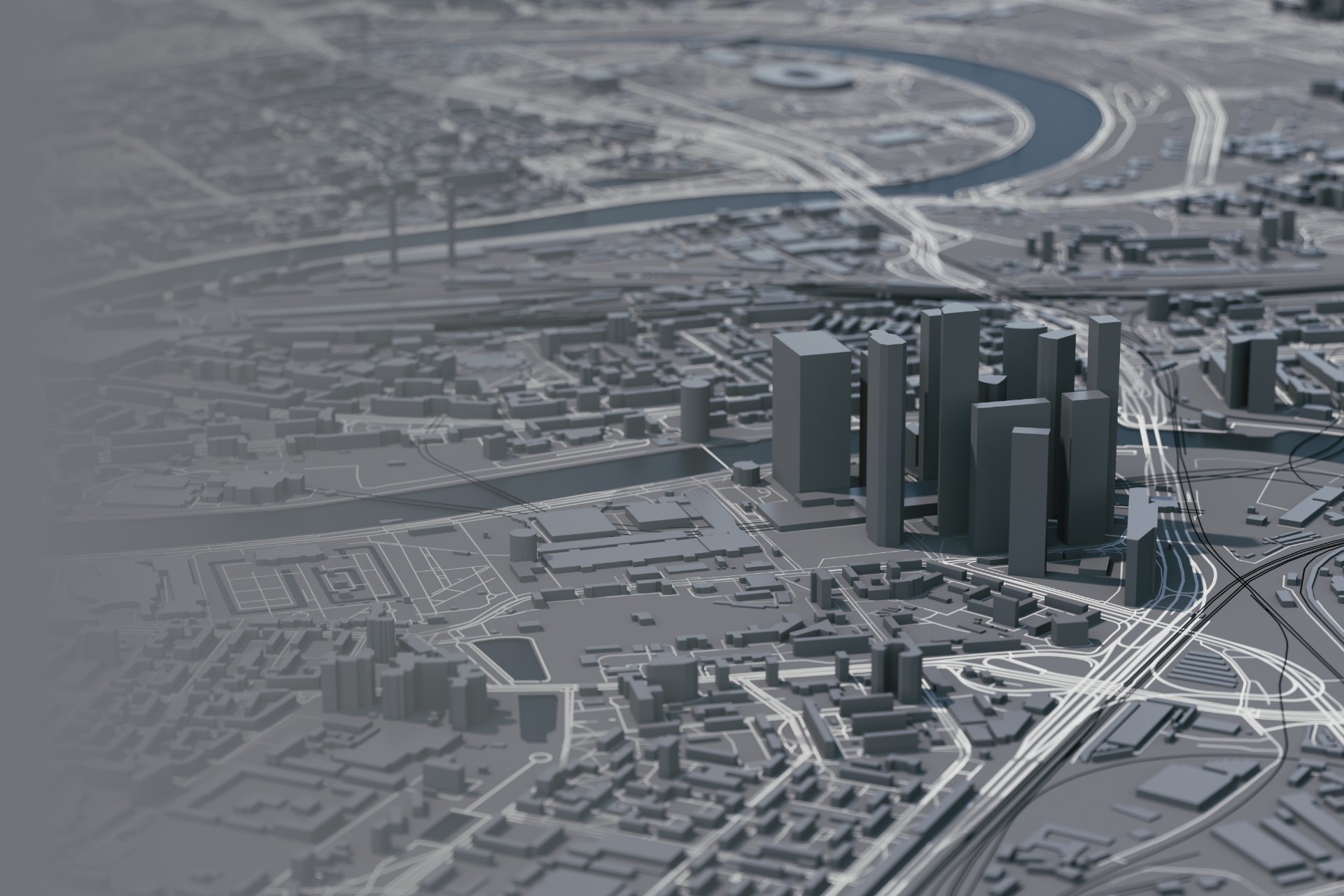
Birds-eye view of any location on the earth's surface in a snap!
Affine
AI Practices
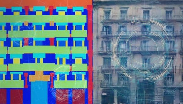
Satellite remote sensing has become one of the most efficient solutions for surveying the earth at local, regional, and global spatial scales. The technique segments the satellite images to develop the topographic details that can be used for various business applications. The implementation of the segmentation depends on the region of interest, size, and resolution of the satellite images complemented by the technology used to process the image. If you’re looking for a quick and effective way to extract the details of any location on the earth’s surface, Telescope is your one-stop solution.
What is Satellite Image Segmentation, and how does it matter to your business?
Let’s break it down into two parts – definition and overview!
Definition: Satellite image segmentation is a process of dividing an image into smaller regions or segments. This is often done to improve the image’s clarity and to make it easier to analyze. The satellite image segmentation solution can be used to improve the accuracy of land surveys, track the movement of objects, and identify changes in the environment.
Overview: For those who are unaware, satellite image segmentation is the same as image segmentation. It uses landscape images taken from satellites and performs segmentation on them, and provides details like greenery, land, buildings, water bodies, and other details of the specific location on the earth’s surface.
The satellite segmentation process includes two steps: segmentation and classification. Images can be created from image type categories, or the image scene itself can have a variety of structures and textures. Segmentation is the process of dividing a digital image into multiple segments. The objective is to simplify or transform an image’s representation into a more meaningful form and simpler to analyze. In a nutshell, it is the process of labeling each pixel in an image so that pixels with the same label share specific visual characteristics. The fundamental application of image segmentation is used to find objects and boundaries (lines, curves, and so on) in images.
Why/which business would desperately need a satellite image segmentation solution?
With increasing spatial, spectral, and temporal resolutions of earth-observing systems, geospatial and remote sensing solutions are moving toward a new paradigm of business applications. As a result, satellite image segmentation solutions are gaining popularity.
Businesses can leverage the satellite image segmentation technique to extract quick results of site/land analysis automatically by eliminating manual efforts and enhancing the accuracy of the survey or analysis of a given location. Below are the few use cases of satellite image segmentation solutions that would be gamechanger for businesses across industries.
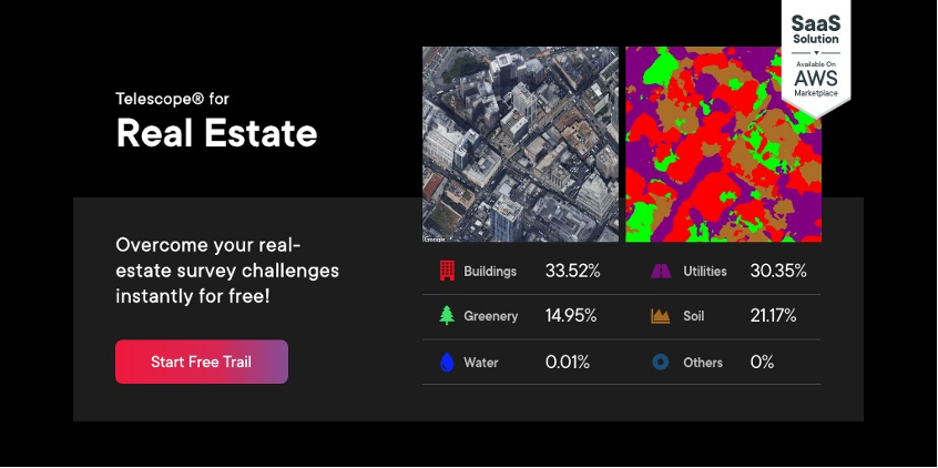
Real-estate: For instance, let’s assume a real-estate professional wants to survey multiple lands to know the plot size so that he can evaluate the price of each property, it would take weeks together to evaluate it manually, plus it requires additional resources. The satellite image segmentation solution uses advanced technologies and spatial analysis to provide important details of the location, such as buildings, roads, grasslands, etc., in just a few seconds while enhancing the accuracy of the survey results.
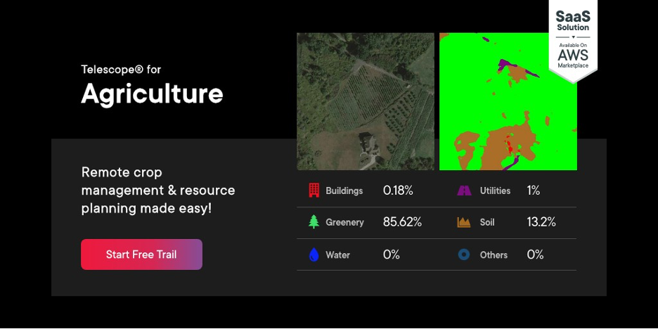
Agriculture: Farmers strive for more sustainable agricultural practices, whether it is crop management or resource planning in warehouses based on yield estimation. Satellite image segmentation can help farmers to understand riparian zones and areas of natural shelter for livestock and wild animals, allowing them to fence off environmentally sensitive areas and reduce the risk of inter-species disease transfer. This technology also reduces the manual efforts in crop management by providing topographic details in seconds.
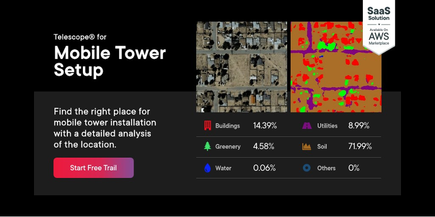
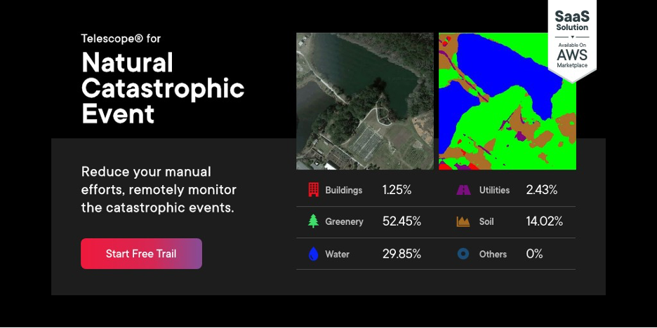
Mobile tower setup: The installation of a mobile phone tower is an intricate process that demands extreme precision. A team of technicians working together from different locations conducts the feasibility analysis to identify the right location for the installation process. Also, installation engineers must be able to measure the distance between the equipment and the target surfaces. Satellite image segmentation minimizes most of these manual efforts, especially in the feasibility analysis process. It provides a detailed view of the site specifying the percentage of buildings, greenery, water, utilities, soil, etc., which will drastically reduce the human resources and the cost incurred to a great extent.
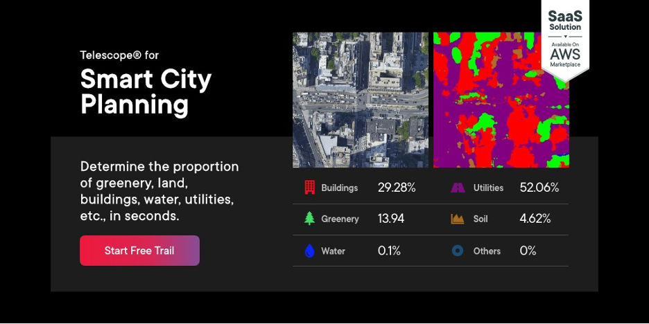
Smart City Planning: A smart city is a broad concept that includes both technology and social and human capital development as fundamental components. As a result, feasibility analysis using structured ad-hoc models appears to be an important factor. To avoid inefficient resource allocation, the approach should consider both the project’s smart characteristics and the city’s actual needs. That’s where satellite image segmentation solutions come in, providing effective and quick ways to assess the given area and provide topographic detail, reducing operating costs while instantly preserving on-ground utility information and other data.
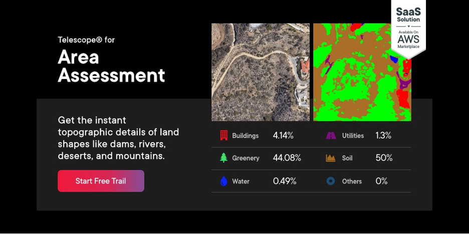
Area assessment: Businesses can use satellite image segmentation to evaluate changes in water bodies or land shapes such as dams, rivers, deserts, and mountains. The extracted topographic details can be used to identify and describe the various types of elements in satellite imagery. It can locate and analyze the given location by comparing them to known features in ground control to see if any surface changes or new features have occurred. This capability largely helps in area assessment and reduces human resources efforts.
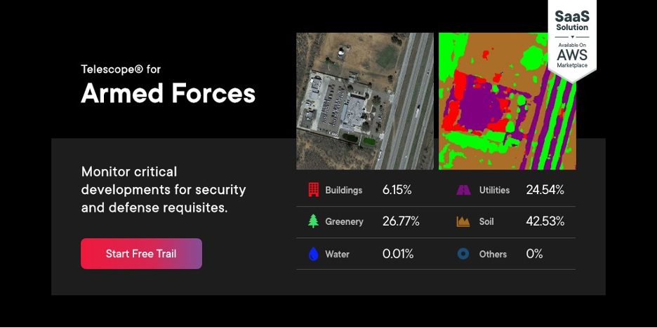
Armed Forces: Satellite image segmentation solution provides a detailed topographic analysis to track vitally critical developments for defense and security prerequisites. These quick details help armed forces to monitor particular areas at regular intervals. This solution also paves remote monitoring of major construction projects, infrastructure development, power generation facilities, mining activities, and so on.
Natural Catastrophic Event: Identifying the regions impacted by a disaster is critical for effectively mobilizing relief efforts. Satellite image segmentation solution with its unique capability of analyzing vast coverage of the ground surface is a valuable resource that can be leveraged to monitor disasters such as volcanic eruptions, wildfires, and floods, among other things, in an attempt to improve life safety, reduce risk, and build resilience to natural catastrophes.
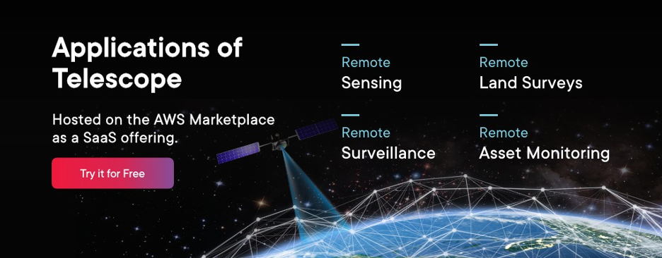
How can Telescope solve your business problems?
Telescope is a next-gen AI solution hosted on the AWS marketplace as a SaaS offering. It delivers automated, fine-grain image segmentation driven by our exclusive deep learning technology, which can help you reduce 40% of the survey cost and 70 % of the reduction in planning time.
Telescope is capable of producing highly intact topographic details using a cutting-edge combination of Computer Vision and GIS technologies. It allows you to automatically retrieve high-resolution satellite images of sites up to 100 square kilometers. You can analyze any location on the earth’s surface and get instant results to find the percentage of greenery, land, buildings, water bodies, etc.
About Author
Affine AI Practice is an expert in delivering cutting enterprise solutions powered by Artificial Intelligence. It has some of the brightest minds in the industry developing avant-garde, scalable AI solutions that leverage revolutionary models and modern research.
Lorem Ipsum is simply dummy text of the printing and typesetting industry. Lorem Ipsum has been the industry's standard dummy text ever since the 1500s, when an unknown printer took a galley of type and scrambled it to make a type specimen book. It has survived not only five centuries, but also the leap into electronic typesetting, remaining essentially unchanged.